Station
of the Week
(10th August 2002)
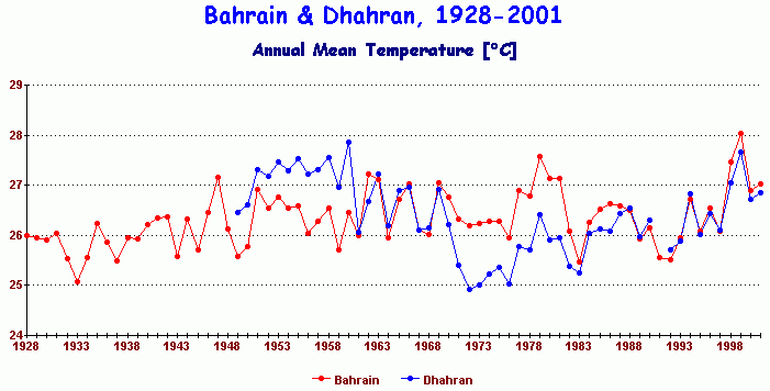
![]()
Dhahran & Bahrain, Persian Gulf, 1928-2001
 |
These two
stations, Dhahran on the Gulf coast of Saudi Arabia and Bahrain (an island in the Gulf), are only 31 miles apart.
But their mutual trends make little sense
at all. Bahrain shows a long-term warming trend of about 1°C, but
Dhahran shows a `U' shaped trend, warm in the mid-century period, cooler
during the 1970s and then warming again during the 1980s and 1990s.,
with the warmest period in the 1950s.
1999 was the warmest year at Bahrain, but 1961 was the warmest at Dhahran. The sharp cooling in the 1970s at Dhahran does not show up at Bahrain. 1933 was the coolest year at Bahrain, while 1972 was the coolest at Dhahran. What are we to make of such contradictory trends from two stations so close together, and both influenced by the sea? |
| Clearly, they
can't both be right, and it would be scientific folly to merely average
them together. Unlike many station pairs shown on `Station of the
Week' which validate each other with mutually consistent trends, these
two invalidate each other since their trends are in no way
mutually consistent.
Station data from large regions of the world are equally contradictory which is one reason why the satellite record is the preferred method of determining the temperature trend of the world as a whole. |
|
| Commentary
by Dr Tim Ball:
You're correct to question the inconsistencies between the two stations
Dhahrain and Bahrain. I have studied a heat island, Winnipeg Manitoba, and written on the issue. Winnipeg was a good study because it is
located on a large flat plain and there are no urban areas within 500 km. There is also a distinct difference in seasons. Commentary by Miceal O'Ronain The temperature exchange between Bahrain & Dhahran are seasonally dependant. Dhahran is warmer during the Spring and Summer, while Bahrain is warmer during the Fall and Winter. Attached is a graph which shows this. Note that for the time period of 1950 to 1960 Dhahram is warmer and 1969 to 1983 when Bahrain was warmer. From the season graphics it would appear the Dhahran is the area which is undergoing the major changes in temperature. Bahrain is relatively constant in temperature for each season.
|
Return to "Still Waiting For Greenhouse"
