|
Heat Wave in Europe:
The Mystery Unveiled
by Eduardo Ferreyra
(16th
September, 2003)

The
recent heat in Europe made headlines in the media
and was used as evidence
that "global warming" is a fact.
Guess what: human activities had nothing
to do with it.
After a brief review of recent history and the fundamentals of
meteorology
and climatology, it has been possible to determine that the causes of the
recent heat in Europe has its origins in a climatic phenomenon known for
many decades as the "Jet Stream",
strong winds whirling around the North Pole, having a decisive influence
on the Northern Hemisphere and the rest of the world. Let us see in detail
what is this thing called the "Jet Stream".
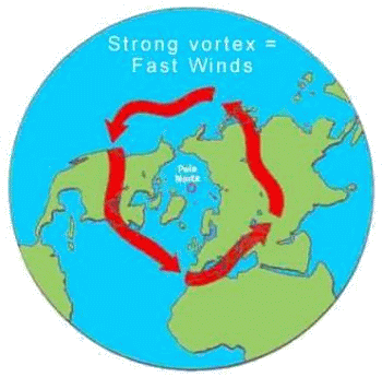
It is a current of very strong winds in the stratosphere whirling around
the North Pole, from west to east, and they do it varying speeds, for not very well understood reasons. Some years they blow at very high speeds,
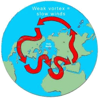
making the current fairly straight; other years they slow down and start
'snaking' and twisting in their path, making deep entrances to the equator,
and far north to the North Pole. Figure 1 (and the next ones) gives
some idea
about how climatologists understand this process.
 
Figure 1: THE JET STREAM
Like
a snake chasing its own tail, the westerly winds undulate around the globe
tracing the trajectory of the Jet Stream in the high troposphere. A strong
circulation corresponds to a compressed circumpolar vortex; a weak circulation
corresponds to a highly irregular and undulating Jet Stream. Such configurations
severely affect the climate in the Northern Hemisphere.
When the circumpolar vortex is intense, and the Jet Stream blows strong,
it follows a path approximately parallel to the Polar regions, with few meanders.
The curves are gentle. The southern climatic regions have more space to move
north, monsoons arrive with welcome regularity, and the temperate regions
enjoy mild years without great temperature or rain extremes.
However, when the vortex becomes weak, the main westerly winds current
flows lazily and makes a wider zig-zag; the current turns become more pronounced.
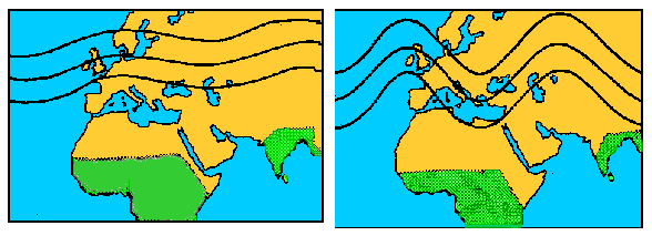
The influence of the vortex intrudes deep into the south, compressing climatic
areas towards the equator and limiting the penetration of the monsoon to the
north (Figure 2).

Figure 2
Variations
in the atmospheric circulation in the Northern Hemisphere directly affect
the monsoon rains
in the Sahel. The strong eastward zonal circulation allows
the monsoon rains to extend farther north.
When the zonal circulation is
weak it is easily diverted pushing the rains southward. The area in green
shows in schematic form the extension of the
monsoon in each case.
At the same time, in
the temperate region enclosing North America and Europe, the now slower Jet
Stream and its accompanying depressions at the surface (low pressures) can
be diverted by other atmospheric general circulation factors. The regions
where the atmospheric pressure is high – anticyclones
– behave as hills or stability islands in the atmosphere around which
flow the Jet Stream and its depressions (low pressures or "cyclones").
Unlike real mountains, high atmospheric pressures are temporal features and also move eastwards in those latitudes.

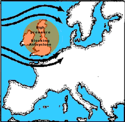
Figure 3
The
weak circulation also creates problems farther north. With strong circulation,
depressions carrying rains generally travel through Great Britain and enter
the European continent. With a weak circulation, instead, "blocking anticyclones"
can settle in some regions deflecting rain carrying currents, causing droughts
and heat waves, as happened in Great Britain during the summer
of 1976 and
the recent summer of 2003.
|
Anyone can try to predict the
next 24 hour weather assuming the high pressure systems seen on the weather
charts will move slightly to the east, carrying along dry and good weather,
while the low pressures will flow around their flanks carrying rain and snow.
On occasions, however, for not too well understood reasons, a high pressure
system remains "nailed" in some place. This is known as a "blocking anticyclone"
and can remain there for days, weeks, even months, acting as a real mountain
around which all other weather systems must flow. Given that anticyclones
are areas of clear and calm air, the geographic regions under them experience
dry and good weather in summer, and cold weather with nocturnal frosts in
winter. A summer high that remains too long in any place soon becomes a problem:
it can be easily provoke a drought or a heat wave
(See figure 3).
All the available scientific data indicates that the climatic extremes which
have occurred since the early 70s are directly related
to an expansion and shrinking of the circumpolar vortex that, has not only
pushed the monsoon southwards, but has also allowed the return, with an
undesirable
frequency, of blocking anticyclones, guiding the low pressure
systems - and their load of humidity - along the extreme meanders north and
south of their main trajectories west-east around the world. |
History Repeat Itself - Once More
Reviewing recent climate history, we can see that the
anomalous weather is not a strange event.
This might sound weird - at first glance. The reason is, we like to think about the
normal weather
as the one which is not too cold, nor too warm, neither too rainy nor too dry.
I am sorry to disappoint you, but it is one thing for us to wish for a
particular kind of weather, and quite another to see how things really are - and all this
without having to blame anybody else other than Mother Nature herself.
Although the winter of 1974-1975 in Great Britain was mild, in June
1975 a snowfall fell in London, the first such event for that time of the
year in the 20th Century. Something similar happened this June of 2003 in
Moscow. Snowfalls in June - weird. Global warming, when? Immediately, giving
fodder to the yellow press tabloids, the out of season cold was followed by the
warmest months of July and August in many years. Overall, 1975 was one of
the driest of the 20th Century caused by a "blocking anticyclone"
in western Europe. From May 1975 through April 1976, the period was the driest
12 month period ever recorded in Great Britain, and the last thing anyone
could expect was another baking summer. However, 1976 made 1975 look cool.
The blocking anticyclone remained over England one week after another – exactly as it did in 2003. Nothing new under the
sun there.
Once the warmest month in the century was over, and after more than
a year of drought, the Thames dried completely along 15 kilometres from its
source, and many dams were left with a fifth of their capacity. The French
grain crop dropped 25% while all western Europe baked under the sun. As it happened again this year of 2003. But similarities do not stop there.
In 1976, as in 2003, the story in eastern Europe was different. The blocking anticyclone
situated over Europe had kept England, France and neighbouring regions dry
and hot. But the low pressure systems, following the undulating path of the
Jet Stream, had to go somewhere else with their load of humidity gathered
during their journey through the Atlantic Ocean. Most of them chose
the northern edge of the blocking anticyclone – the portion of the Jet Stream
driven to the north – and fell afterwards over the Baltic region around
Leningrad (St. Petersburg) and Moscow, pouring heavy rains there and causing
flooding – in the exact same way they did this summer of 2003.
History repeats itself after 27 years, without global warming having anything
to do with it. The Jet Stream is to blame - or perhaps God.
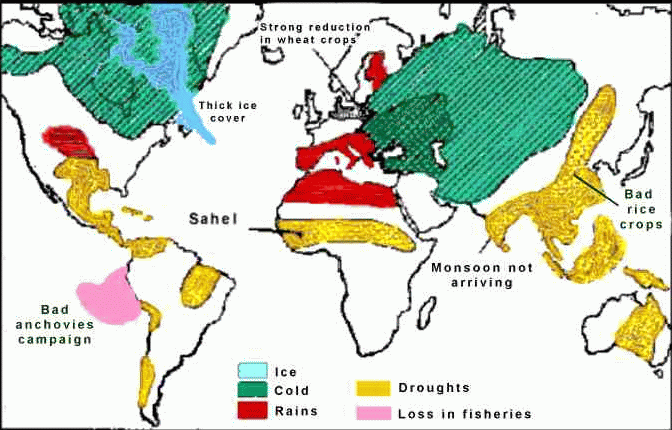
Let us see the way the circumpolar vortex affected the whole planet
in 1972 – not just the Northern Hemisphere, as a way to demonstrate the powerful
influence of this climate feature:

Figure 4
1972
was an unusual bad weather year around the world. Droughts and bad crops
are shown in detail in
the map. some climatologists related these events
with a global cooling (among them Stephen Schneider,
a CEO for the greenhouse
industry), something that seems to be happening – with increasing speed
& power
Winter Too
While all this was happening in Europe, the Great Plains in the northern part of central USA had experienced,
since January 10th to the January 12th,
1975, one of the worst blizzards in the history of that region. These kinds
of deep-freezing climatic events have been repeating themselves with great
regularity in the last years, particularly since the late 80s – when Time
magazine dedicated its first cover of 1989 to the "warmest year ever recorded", 1988 –
just two weeks before one of the worst blizzards ever recorded came down over the entire country.
The winter of 2003 in the Northern Hemisphere broke all records in freezing
temperatures, and the ice in Finland came 15 days earlier than usual. Summer
temperatures in the Southern Hemisphere were mild and cooler than normal.
There is nothing strange in this, since this coincides with
diminishing solar activity and sunspots.
Astrophysicists predict a new Double Minimum (Gleissberg)
for the year 2030,
a solar condition that will have a freezing influence on Earth, taking temperatures
down to the same as those of the Little Ice Age of 1610 onwards, when the
Double Maunder and Spörer Minima occurred. The decrease in the number of
sunspots is slow, but steady, and this will make temperatures go down until
they reach the ones during Galileo's time.
This has been seen during the long and cold winter in the Southern Hemisphere, where subzero temperatures were recorded
during a period of many consecutive days,
an indicator that the prophesised catastrophic global warming has no signs
of revealing itself. A mild and cool 2003 summer, and the late frosts and
spring snowfalls in the Andes and Cordoba Sierras of South America were unusual, suggesting
that a slight cooling is on its way. Everything seems to indicate we are
heading to a new Little Ice Age and, as we are at the end of the Holocene
climatic period, it is quite feasible that the planet will slide slowly towards
a new glaciation.
Conclusion
Data in climatic records are curious, to say the least. Let us see. Since
1973 until 1978, climatologists recorded the following: The coldest winter
since 1740; the driest since 1743; the mildest since 1834; the biggest drought
since 1725; the warmest month of July (1976) since recordings began about
300 years ago. The extreme conditions continued with an almost nonexistent
summer in Europe in 1978, followed by an extraordinarily good and dry autumn
that broke all records. In January 1979, Great Britain suffered the worst winter
ever recorded - 2003 was worse yet.
In January 1981, The Times of London published a headline: HUNDRED DIE WHILE COLD GRIPS THREE CONTINENTS,
and reported the difficulties caused by strong snowfalls in Spain and
southwest France, plus a "more than usual" bad weather in Japan and a
state of emergency declared in Florida, after two days of severe frosts provoked
serious damage to crops (tomatoes, citrus, and sugar
cane). At this point
it is worth noting that the "frost lines" (isotherms), the southern limit of
frosts, annually drawn by the US Weather Service show that they have been
gradually moving 150 kilometres to the south for the last 50 years or so
- from Jacksonville to Orlando. You cannot grow oranges north of Orlando
if you want to have a decent crop.
In those years, China suffered one of the worst climatic calamities
since the civil war of the 40s. In Hubei province, 800 kilometres south
of Beijing, the main problem was floods that destroyed schools, hospitals,
electric utilities, bridges, roads, and 210,000 homes, causing damage estimated
in economic terms at 1 billion dollars, and the loss of 2,5 million tons
of grain.
In Hebei province, around Beijing itself, the problem was drought. In 1980, the rain monthly mean never went over 80% of "normal", and in many cases didn't even reach 30%.
The losses in grain summed up to 4,5 million tons, and the level of underground
water went so low that the provision of "drinkable" water was compromised.
The problems for the suffering population were further exacerbated by a terrible winter.
China had to resort to help from Western countries, but the trouble was
they had to deal with their own problems, especially when the drought was repeated
again in the USA for a second year in a row, in 1981.
Nobody will be surprised now to know that the drought was caused by
a blocking anticyclone over the western part of the USA. Not one, but three droughts, in the west, in the corn belt, and in the northwest, were the consequences of a complex blocking system
that affected the whole of North America. The meteorological science is still
unable to explain accurately why all that set of events had to occur in
a particular year, nor can it predict the formation of such a blocking system.
However, the science can put all those problems in their adequate historical
perspective. We don't know exactly when blocking systems will happen, but
we can see that the increasing frequency of droughts, heavy rains, and other
climatic extrema should make us expect a return to the climatic conditions
prevailing during the last millennium.
Climatology has received new contributions from other scientific
fields, especially from astrophysics and astronomy. The most recent research
in these fields now allows us to predict, with high accuracy, the increase and
decrease of solar activity, according to the position of the Sun relative to the
baricentre (centre of masses of the solar
system), as the planets orbit
around the Sun. It has been proved, beyond any doubt or speculation, that
the sun's magnetic cycles have a decisive influence over important climatic
events such as the El Nińo Southern Oscillation (ENSO), the amount of cosmic rays entering Earth's atmosphere
(which determines the formation of clouds), and other vital
variables such as the
North Atlantic Oscillation. All these powerful factors, interacting within
a very complex system such as the atmosphere, makes the role of CO2 as the main driving force behind global warming, each day more insignificant and meaningless.
This also exposes the useless futility of general circulation models, inefficient imitations of the Earth's climate
used by the greenhouse
industry in order to promote scare campaigns about the climatic future of
the planet, trying to impose restrictive measures on fossil fuel users – with
more geopolitical implications than any real intention to stop an unreal warming
that has not happened, not shows any signs of ever happening.
Recommended Reading
1. Keplerian Planetary and Climatic Dynamics.
"The “Solar Jerk”, The King-Hale Cycle, and the Challenge to Climate Science"
by Rhodes W. Fairbridge, Emeritus Professor of Geology at Columbia University
in New York.
2. July snow chills Interior:
What the heck happened to July? It felt more like mid-October on Tuesday
and Wednesday, as records fell all over the heart of Alaska.
3. SOLAR WIND NEAR EARTH: INDICATOR OF VARIATIONS IN GLOBAL TEMPERATURE: Scientific
paper by Dr. Theodor Landscheidt (Schroeter Institute for Research in Cycles
of Solar Activity, Germany), published in Proceedings of the 1st Solar
& Space Weather Euroconference, 'The Solar Cycle and Terrestrial Climate',
Santa Cruz de Tenerife, Tenerife, Spain, 25-29 September 2000 (ESA SP-463,
December 2000). [Published here by Dr. Landscheidt's kind permission.]
4. SOLAR FORCING OF EL NIŃO AND LA NIŃA:
Scientific paper by Dr. Theodor Landscheidt (Schroeter Institute for Research
in Cycles of Solar Activity, Germany), published in Proceedings of the
1st Solar & Space Weather Euroconference, 'The Solar Cycle and Terrestrial
Climate', Santa Cruz de Tenerife, Tenerife, Spain, 25-29 September 2000 (ESA
SP-463, December 2000). [Published here by Dr. Landscheidt's kind permission.]
5. New Little Ice Age Instead of Global Warming?: A superb scientific paper by Dr. Theodor
Landscheidt:
6. The Global Warming Folly: (by Prof. Zbigniew
Jaworowski) - "Despite
billions of dollars and millions of propaganda headlines, the global warming
prophesied by the climate modelling industry is not scientifically real."
7. Modeling climatic effects of anthropogenic carbon dioxide emissions: unknowns and uncertainties:
Scientific paper by Dr. Willie Soon, S. Baliunas, Sherwood B. Idso, Kirill Ya. Kondratyev, and Eric S.
Posmentier: A likelihood of disastrous global
environmental consequences has been surmised as a result of projected increases
in anthropogenic greenhouse gas emissions. These estimates are based on computer
climate modelling, a branch of science still in its infancy despite recent
substantial strides in knowledge. This paper demonstrates why computer modelling
can not be trusted at all.
8. A Global Warming Primer:
by by Gerald E. Marsh, physicist at Argonne National Laboratory - The purpose
of this primer is to help the reader determine whether our understanding
of the Earth's climate is adequate to predict the long term effects of carbon
dioxide released as a result of the continued burning of fossil fuels. "...
Given the uncertainties described above, and the current state of coupled
ocean-atmosphere general-circulation models, the predictions of these models
cannot and do not form a sound basis for public policy decisions."
A "must read" report.
|
