What
is the El-Niño Southern Oscillation?
 The El-Niño Southern Oscillation is the result of a cyclic warming
and cooling of the surface ocean of the central and eastern Pacific. This
region of the ocean is normally colder than it's equatorial location would
suggest, mainly due to the influence of northeasterly trade winds, a cold
ocean current flowing up the coast of Chile, and to the upwelling of cold
deep water off the coast of Peru.
The El-Niño Southern Oscillation is the result of a cyclic warming
and cooling of the surface ocean of the central and eastern Pacific. This
region of the ocean is normally colder than it's equatorial location would
suggest, mainly due to the influence of northeasterly trade winds, a cold
ocean current flowing up the coast of Chile, and to the upwelling of cold
deep water off the coast of Peru.
At times, the influence of these cold water sources wane, causing the surface
of the eastern and central Pacific to warm up under the tropical sun -
this is an EL-NIÑO event. This results in heavy
rainfall in South America, but severe droughts in eastern Australia. The
more intense the El-Niño, the more intense and extensive the Australian
droughts.
At other times, the injection of cold water becomes more intense than usual,
causing the surface of the eastern Pacific to cool - this is a LA-NIÑA
event. This results in droughts in south America and heavy rainfall, even
floods, in eastern Australia. In this way, Australia experiences it's characteristic
cycle of droughts and floods - all caused by the El-Niño/La-Niña
cycle described above.
For more detailed information on El-Niño see the Queensland
DNR `Long Paddock' website, and the NOAA
El-Niño Theme Page.
The latest Global
Sea Surface Temperature from the University of Wisconsin-Madison (all
rights reserved). Particularly note the ocean temperatures in the eastern
Pacific near Ecuador, Peru and the Galapagos Is., the source of the El-Niño
Southern Oscillation.
Why
are "El-Niño" and "La-Niña" so named?
"El-Niño" is named after a Peruvian
Christmas festival where the warming of the waters off Peru is said to
occur near the birthday of "The Boy" (El
Niño), or the Christ child. Meteorologists thus named the
phenomenon the "El-Niño Southern Oscillation", or ENSO
for short. The reverse phenomenon, the cooling of the eastern Pacific waters,
was at first called "Anti-El-Niño", until it was realised
that this literally meant the Anti-Christ ! To avoid this unfortunate connotation,
it was renamed "La-Niña" (or
"The Girl").
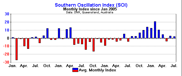
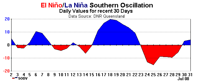
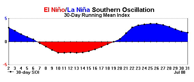
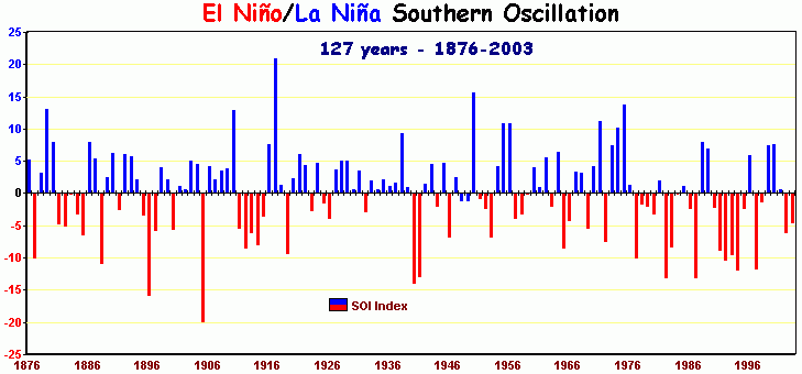
What
is the Southern Oscillation Index?
It has been found that the cyclic warming and cooling of the eastern and
central Pacific leaves it's distinctive fingerprint on sea level pressure.
In particular, when the pressure measured at Darwin is compared with that
measured at Tahiti, the difference between the two can be used to generate
an "index" number. When there is a positive
number, we have a La-Niña (or ocean cooling),
but when the number is negative we have an El-Niño
(or ocean warming).
|
